Long-Term Monitoring Site at North Inlet Winyah Bay National Estuarine Research Reserve
Parameters: Active Fluorescence
The North Inlet-Winyah Bay National Estuarine Research Reserve (NEER) is one of 26 sites around the coastal US. Each reserve receives funding from the National Oceanic and Atmospheric Administration (NOAA) and matched resources from the host state agency. The North Inlet-Winyah Bay Reserve is hosted by the University of South Carolina, Belle W. Baruch Institute for Marine and Coastal Sciences.
The Reserve encompasses 12,327 acres of tidal marshes and wetlands. North Inlet-Winyah Bay NERR features high quality, ocean-dominated waters and salt marshes in North Inlet, contrasting with the brackish waters and marshes of Winyah Bay. The bay's estuary is dominated by riverine discharges from a watershed impacted by agricultural, municipal and industrial development. Former rice fields and canals provide another system for study within the Reserve.

Figure 1. Oyster Landing (OL) monitoring site in South Carolina
The Oyster Landing (OL) meteorological and water quality monitoring site, located at the end of the pier, is considered a fairly pristine and undisturbed area. The pier stretches into the upper reaches of Crabhaul Creek in the mid-western portion of North Inlet. The sampling site is located approximately 2.8km from the headwaters of Crabhaul Creek. The creek directly drains pine forested uplands and wetlands. Salinity can range from 0-32 ppt. and average tidal range is approximately 1.4m.
The creek has an average depth of ~2m MHW and an average width of ~150m at MHW. The bottom is comprised mostly of oyster shell hash with some fine sediment and detritus.
The PhytoFlash was deployed at a depth of 0.5 m and was logging at 15-minute intervals. An ISCO sampler was programmed to collect samples at two-hour intervals. Samples were processed for extracted chlorophyll a, inorganic nutrients, and absorbance of filtered water samples.

Figure 2. North Inlet Winyah Bay National Estuarine Research Reserve, South Carolina
(latitude 33o20'58" longitude 79o11'34")

Figure 3. Turner Design’s PhytoFlash deployed in the Self-Contained Mode

Graph 1. Data reflecting absorbance, determined on a spectrofluorometer at 355nm, and water level over two tidal cycles (January 25, 2006). Absorbance is negatively correlated to water level, suggesting a strong export of colored fractionated water on the

Graph 2. Absorbance, water level, and PhytoFlash blank data were used a posteriori to “blank correct” for the PhytoFlash yields.
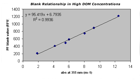
Graph 3. Blanks measured on the PhytoFlash and spectrofluorometer by using GF/F filtered sample water at 19 degrees C. It is possible to derive corrected blank values from the PhytoFlash using additional absorbance measurements.
Author: Dr. Erik Smith & Tracy Buck
Institution: University of South Carolina Belle W. Baruch Institute for Marine and Coastal Sciences
Location: South Carolina, USA